
CC BY-SA 4.0
Nikko heritage and nature plans center on Toshogu and the surrounding mountain area. Image: Koichi Sato / CC BY-SA 4.0.
- Credit
- Koichi Sato
- Source
- https://commons.wikimedia.org/wiki/File%3ANikko_toshogu_shrine.jpg

CC BY-SA 4.0
Kamakura day trips are represented by its coast and temple heritage. Image: Gilles Desjardins / CC BY-SA 4.0.
- Credit
- Gilles Desjardins
- Source
- https://commons.wikimedia.org/wiki/File%3AKamakura_-_Grand_Bouddha.jpg
CC BY-SA 4.0
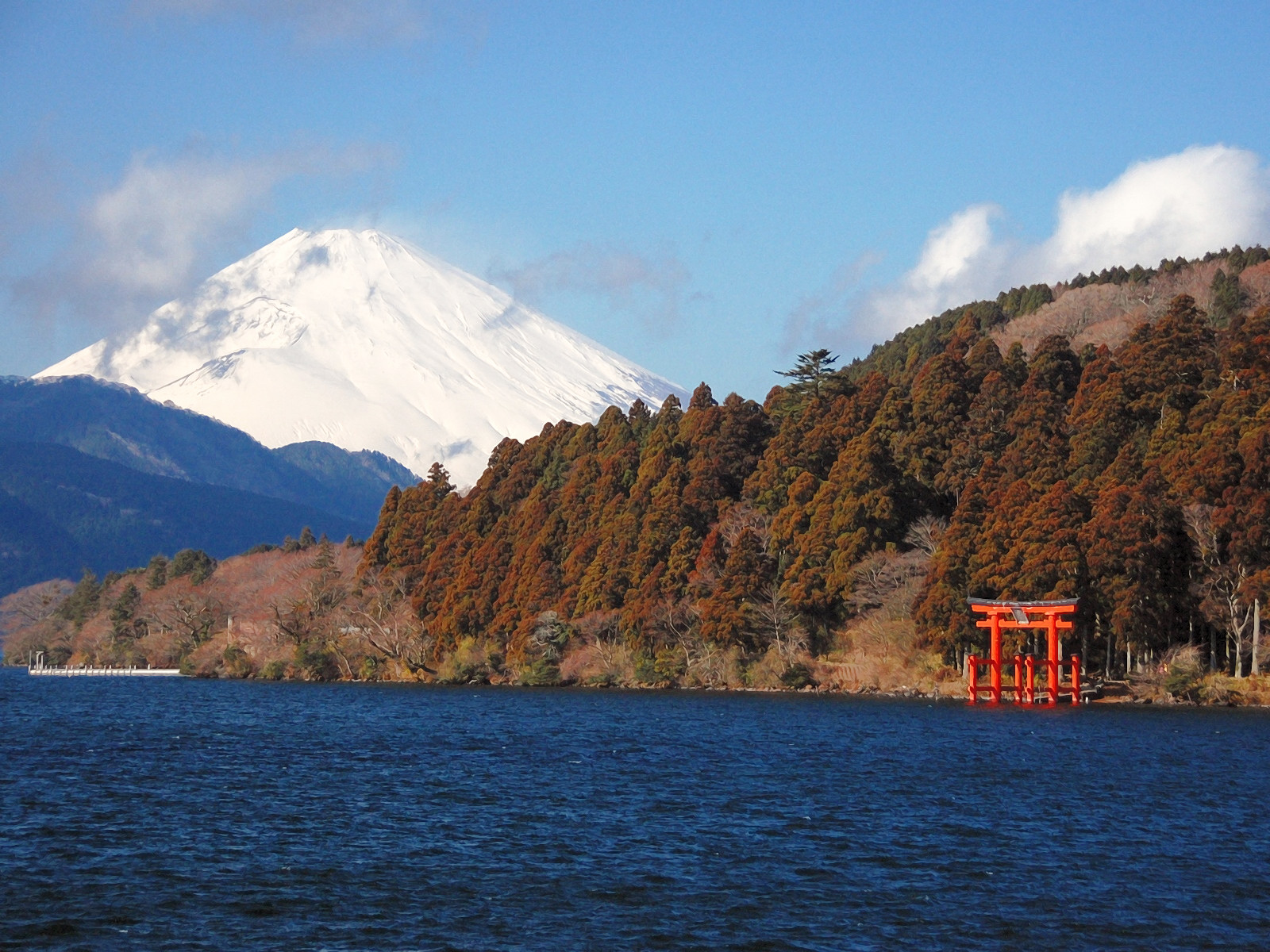
Hakone loop planning is represented by Lake Ashi and Mount Fuji views. Image: Kentagon / CC BY-SA 4.0.
- Credit
- Kentagon
- Source
- https://commons.wikimedia.org/wiki/File%3ALakeAshi_and_MtFuji_Hakone.JPG

CC BY-SA 3.0
Otaru evening plans are represented by the canal district. Image: t-konno / CC BY-SA 3.0.
- Credit
- t-konno
- Source
- https://commons.wikimedia.org/wiki/File%3A%E5%B0%8F%E6%A8%BD%E9%9B%AA%E3%81%82%E3%81%8B%E3%82%8A%E3%81%AE%E8%B7%AF2013%EF%BC%88Otaru_Snow_Light_Path_2013%EF%BC%89_-_panoramio_(1).jpg

CC BY-SA 2.0
Kerama day plans are represented by island beaches and snorkeling waters. Image: Joseph Bylund / CC BY-SA 2.0.
- Credit
- Joseph Bylund
- Source
- https://commons.wikimedia.org/wiki/File%3ARi_Island_viewed_from_Tokashiki%2C_Okinawa%3B_January_2020.jpg

CC BY-SA 4.0
Setouchi planning is represented by island and port scenery. Image: OKJaguar / CC BY-SA 4.0.
- Credit
- OKJaguar
- Source
- https://commons.wikimedia.org/wiki/File%3ABedroom_window_view_of_Seto_Inland_Sea_at_dawn%2C_Onomichi%2C_Ikuchi_Island%2C_Japan.jpg

CC BY 2.0
Nagano side trips are represented by Jigokudani Snow Monkey Park. Image: Chi King / CC BY 2.0.
- Credit
- Chi King
- Source
- https://commons.wikimedia.org/wiki/File%3ASnow_monkey_park_at_Jigokudani_Yaenkoen_(Nagano-Japan)_(14763991244).jpg

CC BY-SA 4.0
Sumida River evening walks pair riverside paths with Tokyo Skytree views. Image: Basile Morin / CC BY-SA 4.0.
- Credit
- Basile Morin
- Source
- https://commons.wikimedia.org/wiki/File%3AAsahi_Breweries_headquarters_building_with_the_Asahi_Flame_and_Skytree_at_blue_hour_with_full_moon%2C_Sumida-ku%2C_Tokyo%2C_Japan.jpg

CC BY-SA 3.0
Sapporo travel planning is represented by Odori Park and central Sapporo. Image: Nkns / CC BY-SA 3.0.
- Credit
- Nkns
- Source
- https://commons.wikimedia.org/wiki/File%3AHokkaido_Sapporo_Odori_Park.jpg

CC BY-SA 3.0
Late arrivals are represented by Narita Airport terminal facilities. Image: Syohei Arai (talk) / CC BY-SA 3.0.
- Credit
- Syohei Arai (talk)
- Source
- https://commons.wikimedia.org/wiki/File%3ANarita_Airport_Station-2008.02.02_1.jpg
CC BY-SA 3.0
Sapporo travel planning is represented by Odori Park and central Sapporo. Image: Nkns / CC BY-SA 3.0.
- Credit
- Nkns
- Source
- https://commons.wikimedia.org/wiki/File%3AHokkaido_Sapporo_Odori_Park.jpg

CC BY 2.0
IC card travel in Tokyo is best illustrated by station gates and Suica/PASMO use. Image: Tim Adams from San Francisco / CC BY 2.0.
- Credit
- Tim Adams from San Francisco
- Source
- https://commons.wikimedia.org/wiki/File%3A%E3%81%AE%E3%82%8A%E3%81%93%E3%81%97%E7%B2%BE%E7%AE%97_2014_(13154067205).jpg

CC BY-SA 4.0
Tokaido Shinkansen N700 is used to match the article's destination or travel topic. Image: Charlie fong / CC BY-SA 4.0.
- Credit
- Charlie fong
- Source
- https://commons.wikimedia.org/wiki/File%3AN700_in_Tokaido_Shinkansen_%26Mt.Fuji.jpg

CC BY-SA 3.0
Okinawa planning is represented by main-island and outer-island beach scenery. Image: Mokkie / CC BY-SA 3.0.
- Credit
- Mokkie
- Source
- https://commons.wikimedia.org/wiki/File%3AKouri_beach%2C_Okinawa.jpg

CC BY 2.5
Biei Hokkaido landscape is used to match the article's destination or travel topic. Image: 663highland / CC BY 2.5.
- Credit
- 663highland
- Source
- https://commons.wikimedia.org/wiki/File%3A140726_Shikisai-no-oka_Biei_Hokkaido_Japan02n.jpg

Public domain
Kansai and Osaka planning is represented by central Osaka landmarks. Image: Naniwa Meisho / Public domain.
- Credit
- Naniwa Meisho
- Source
- https://commons.wikimedia.org/wiki/File%3ADotonbori_Osaka_1910.jpg

CC BY 3.0
Kyoto articles are represented by recognizable temple and historic street scenes. Image: Kovacs Bela-Hungary / CC BY 3.0.
- Credit
- Kovacs Bela-Hungary
- Source
- https://commons.wikimedia.org/wiki/File%3AKiyomizu-dera_Temple%2C_Kyoto_-_panoramio.jpg

CC BY 4.0
A Tokyo travel scene represents planning topics based around Japan’s busiest gateway. Image: David Kernan / CC BY 4.0.
- Credit
- David Kernan
- Source
- https://commons.wikimedia.org/wiki/File%3AMinato_City%2C_Tokyo%2C_Japan.jpg

CC BY-SA 2.0
Rail planning is represented with a Japan Shinkansen or JR train scene. Image: calflier001 / CC BY-SA 2.0.
- Credit
- calflier001
- Source
- https://commons.wikimedia.org/wiki/File%3ARAIL_STAR_SHINKANSEN_BULLET_TRAIN_AT_HIROSHIMA_STATION_JAPAN_JUNE_2012_(7454701202).jpg

CC BY-SA 4.0
Tokyo disaster prevention Japan is used to match the article's destination or travel topic. Image: Theodore Xu / CC BY-SA 4.0.
- Credit
- Theodore Xu
- Source
- https://commons.wikimedia.org/wiki/File%3ADisaster_Prevention_Warehouse_of_Nishicyokai%2C_Tokyo.jpg

Public domain
Shojin ryori Kyoto is used to match the article's destination or travel topic. Image: Ph0kin / Public domain.
- Credit
- Ph0kin
- Source
- https://commons.wikimedia.org/wiki/File%3AShojin_ryori_ryuanji.jpg

CC BY 2.0
Luggage planning is represented by station storage and transfer scenes. Image: MiNe / CC BY 2.0.
- Credit
- MiNe
- Source
- https://commons.wikimedia.org/wiki/File%3ASign_of_How_to_use_a_Coinlocker_in_Shinjuku_Station.jpg

CC BY-SA 4.0
Tokyo Station Marunouchi is used to match the article's destination or travel topic. Image: Basile Morin / CC BY-SA 4.0.
- Credit
- Basile Morin
- Source
- https://commons.wikimedia.org/wiki/File%3APhotographer_taking_a_group_photograph_of_smiling_students_in_front_of_the_Tokyo_station%2C_Marunouchi%2C_Japan.jpg

Public domain
Hokkaido snow winter is used to match the article's destination or travel topic. Image: Michala Garrison, using MODIS data from NASA EOSDIS LANCE and GIBS/Worldview / Public domain.
- Credit
- Michala Garrison, using MODIS data from NASA EOSDIS LANCE and GIBS/Worldview
- Source
- https://commons.wikimedia.org/wiki/File%3ANorthern_Japan%2C_especially_the_island_of_Hokkaido%2C_is_home_to_some_of_the_snowiest_cities_in_the_world_(stormy-snowy-winter-for-hokkaido).jpg
CC BY-SA 4.0
Tokyo Station Marunouchi is used to match the article's destination or travel topic. Image: Basile Morin / CC BY-SA 4.0.
- Credit
- Basile Morin
- Source
- https://commons.wikimedia.org/wiki/File%3APhotographer_taking_a_group_photograph_of_smiling_students_in_front_of_the_Tokyo_station%2C_Marunouchi%2C_Japan.jpg

CC0
Kouri Island Okinawa beach is used to match the article's destination or travel topic. Image: NORTLAUKAU 26088 JP / CC0.
- Credit
- NORTLAUKAU 26088 JP
- Source
- https://commons.wikimedia.org/wiki/File%3AJP_%E6%B2%96%E7%B9%A9_Okinawa_Nago_Kouri_Island_n_Road_Bridge_n_Beach_January_2026_N13P_08.jpg

CC0
Naha Okinawa street is used to match the article's destination or travel topic. Image: Naha Mama Pavilionz / CC0.
- Credit
- Naha Mama Pavilionz
- Source
- https://commons.wikimedia.org/wiki/File%3AJP_%E6%97%A5%E6%9C%AC_Japan_%E6%B2%96%E7%B9%A9_OKINAWA_%E9%82%A3%E9%9C%B8_Naha_%E5%9C%8B%E9%9A%9B%E9%80%9A_KokusaiDori_%E5%A4%A7%E5%B9%B3%E9%80%9A%E5%95%86%E5%BA%97%E8%A1%97_TaiHeiDori_Business_Street_night_January_2024_R12S_01.jpg

Public domain
Okinawa snorkeling advice is represented by reef and beach scenery. Image: Signal Corps Archive from Ireland and United States / Public domain.
- Credit
- Signal Corps Archive from Ireland and United States
- Source
- https://commons.wikimedia.org/wiki/File%3ASC_205560_-_This_is_an_aerial_view_of_the_beach_at_Okinawa_a_few_days_after_Tenth_Army_troops_moved_ashore._(51362208315).jpg

CC BY-SA 2.0
Kyoto night etiquette is represented by Gion or Pontocho streets. Image: einalem from Pontocho street in Nakagyo, Kyoto / CC BY-SA 2.0.
- Credit
- einalem from Pontocho street in Nakagyo, Kyoto
- Source
- https://commons.wikimedia.org/wiki/File%3APontocho_by_einalem_in_Kyoto.jpg

CC BY 2.5
Miyako routes are represented by beaches and island bridges. Image: 663highland / CC BY 2.5.
- Credit
- 663highland
- Source
- https://commons.wikimedia.org/wiki/File%3AYonahamaehama_Miyakojima_Okinawa_Japan01bs3s4592.jpg

Public domain
Yaeyama base choices are represented by Ishigaki Island scenery. Image: NASA / Public domain.
- Credit
- NASA
- Source
- https://commons.wikimedia.org/wiki/File%3ASTS043-608-38_Ishigaki_Island.jpg

CC0
Kouri Bridge Okinawa is used to match the article's destination or travel topic. Image: NORTLAUKAU 26088 JP / CC0.
- Credit
- NORTLAUKAU 26088 JP
- Source
- https://commons.wikimedia.org/wiki/File%3AJP_%E6%B2%96%E7%B9%A9_Okinawa_Nago_Kouri_Road_Bridge_n_Beach_January_2026_N13P_03.jpg
CC0
Kouri Bridge Okinawa is used to match the article's destination or travel topic. Image: NORTLAUKAU 26088 JP / CC0.
- Credit
- NORTLAUKAU 26088 JP
- Source
- https://commons.wikimedia.org/wiki/File%3AJP_%E6%B2%96%E7%B9%A9_Okinawa_Nago_Kouri_Island_n_Road_Bridge_n_Beach_January_2026_N13P_08.jpg
Public domain
Kansai and Osaka planning is represented by central Osaka landmarks. Image: Naniwa Meisho / Public domain.
- Credit
- Naniwa Meisho
- Source
- https://commons.wikimedia.org/wiki/File%3ADotonbori_Osaka_1910.jpg

CC0
Naha first-evening plans are represented by Kokusai-dori or the monorail. Image: Naha Mama Pavilionz / CC0.
- Credit
- Naha Mama Pavilionz
- Source
- https://commons.wikimedia.org/wiki/File%3AJP_%E6%97%A5%E6%9C%AC_Japan_%E6%B2%96%E7%B9%A9_OKINAWA_%E9%82%A3%E9%9C%B8_Naha_%E5%9C%8B%E9%9A%9B%E9%80%9A_Kokusai-dori_sign_route_January_2025_R12S_02.jpg

Public domain
Sakurajima Kagoshima volcano is used to match the article's destination or travel topic. Image: NASA / Public domain.
- Credit
- NASA
- Source
- https://commons.wikimedia.org/wiki/File%3AActivity_at_Sakurajima_Volcano_2010-02-15.jpg

CC BY-SA 3.0
Mount Aso Kumamoto is used to match the article's destination or travel topic. Image: STA3816 / CC BY-SA 3.0.
- Credit
- STA3816
- Source
- https://commons.wikimedia.org/wiki/File%3AMount_Aso_from_Aso_Volcano_Museum.jpg

CC BY-SA 4.0
Hakata yatai Fukuoka is used to match the article's destination or travel topic. Image: Hirho / CC BY-SA 4.0.
- Credit
- Hirho
- Source
- https://commons.wikimedia.org/wiki/File%3AYatai_the_rearcar_running_along_Reisen_D%C5%8Dri_Kami-kawabatamachi_Hakata-ku_Fukuoka_20231123.jpg

CC BY 3.0
Yufuin no Mori JR Kyushu is used to match the article's destination or travel topic. Image: G43 / CC BY 3.0.
- Credit
- G43
- Source
- https://commons.wikimedia.org/wiki/File%3AJR_Kyushu_Kiha_71_Series_DMU_Yufuin-no-mori.jpg

CC BY-SA 4.0
Shikoku routes are represented by pilgrimage temple scenery. Image: そらみみ / CC BY-SA 4.0.
- Credit
- そらみみ
- Source
- https://commons.wikimedia.org/wiki/File%3APoles_showing_the_1st_temple_of_Shikoku_Pilgrimage_on_sando_of_Ryozenji_Temple.jpg

CC BY 3.0
Yakushima forest Japan is used to match the article's destination or travel topic. Image: Σ64 / CC BY 3.0.
- Credit
- Σ64
- Source
- https://commons.wikimedia.org/wiki/File%3AForest_in_Yakushima_06.jpg

Public domain
Miyazaki driving routes are represented by coastal scenery. Image: Japan Coast Guard / Public domain.
- Credit
- Japan Coast Guard
- Source
- https://commons.wikimedia.org/wiki/File%3AKurasaki_Lighthouse_Miyazaki.jpg

CC BY 4.0
Itsukushima Shrine Miyajima Hiroshima is used to match the article's destination or travel topic. Image: Hyppolyte de Saint-Rambert / CC BY 4.0.
- Credit
- Hyppolyte de Saint-Rambert
- Source
- https://commons.wikimedia.org/wiki/File%3AItsukushima_(Miyajima_Hiroshima)_hdsr_Shrine_S5_09.jpg

CC BY-SA 3.0
Sakurajima Kagoshima volcano is used to match the article's destination or travel topic. Image: Hirase / CC BY-SA 3.0.
- Credit
- Hirase
- Source
- https://commons.wikimedia.org/wiki/File%3A20090906_sakurajima_yoshino_kagoshima-ken_japna.jpg

CC BY 2.5
Kumamoto routes are represented by the castle or Mount Aso. Image: 663highland / CC BY 2.5.
- Credit
- 663highland
- Source
- https://commons.wikimedia.org/wiki/File%3AKumamoto_Castle_02n3200.jpg

CC BY-SA 4.0
Tokaido Shinkansen N700 is used to match the article's destination or travel topic. Image: Dr.yellow / CC BY-SA 4.0.
- Credit
- Dr.yellow
- Source
- https://commons.wikimedia.org/wiki/File%3ATokaido_Shinkansen_sharp_turn_in_Musashi-Kosugi_2.jpg

CC BY 2.0
Beppu first visits are represented by onsen steam and hot spring areas. Image: David Stanley from Nanaimo, Canada / CC BY 2.0.
- Credit
- David Stanley from Nanaimo, Canada
- Source
- https://commons.wikimedia.org/wiki/File%3ABeppu_Hot_Springs_(31338411912).jpg

CC BY 2.5
Nagasaki routes are represented by its slope city landscape. Image: 663highland / CC BY 2.5.
- Credit
- 663highland
- Source
- https://commons.wikimedia.org/wiki/File%3ANagasaki_City_view_from_Mt_Inasa01s5.jpg

Public domain
Hokuriku craft and garden routes are represented by Kanazawa. Image: No machine-readable author provided. Jovandavid~commonswiki assumed (based on copyright claims). / Public domain.
- Credit
- No machine-readable author provided. Jovandavid~commonswiki assumed (based on copyright claims).
- Source
- https://commons.wikimedia.org/wiki/File%3AFunsui-first-fountain-in-Japan-kanazawa-kenrokuen-2006-03-04.jpg

CC BY 4.0
Fukuoka food routes are represented by Hakata yatai and city food culture. Image: Nesnad / CC BY 4.0.
- Credit
- Nesnad
- Source
- https://commons.wikimedia.org/wiki/File%3AHakata_yatai_and_yatai_food_-_2024_Sept_24_various.jpeg

CC BY 2.5
Naoshima island art is used to match the article's destination or travel topic. Image: 663highland / CC BY 2.5.
- Credit
- 663highland
- Source
- https://commons.wikimedia.org/wiki/File%3A150505_Chichu_Art_Museum_Naoshima_Island_Kagawa_pref_Japan01s3.jpg
Public domain
Tohoku routes are represented by major regional scenery and festivals. Image: Wikimedia Commons contributor / Public domain.
- Credit
- Wikimedia Commons contributor
- Source
- https://commons.wikimedia.org/wiki/File%3AMatsushima.jpg
CC BY-SA 4.0
Shikoku routes are represented by pilgrimage temple scenery. Image: そらみみ / CC BY-SA 4.0.
- Credit
- そらみみ
- Source
- https://commons.wikimedia.org/wiki/File%3APoles_showing_the_1st_temple_of_Shikoku_Pilgrimage_on_sando_of_Ryozenji_Temple.jpg

CC BY-SA 3.0
Matsuyama city plans are represented by Dogo Onsen. Image: Jyo81 / CC BY-SA 3.0.
- Credit
- Jyo81
- Source
- https://commons.wikimedia.org/wiki/File%3ADogo_Onsen_Station2(Matsuyama_City).JPG

CC BY-SA 3.0
Kochi nature and market trips are represented by castle or coastal scenery. Image: by Reggaeman / CC BY-SA 3.0.
- Credit
- by Reggaeman
- Source
- https://commons.wikimedia.org/wiki/File%3AKochi_Castle_03.JPG

CC BY-SA 4.0
Takamatsu art-island bases are represented by Ritsurin Garden. Image: Vanvelthem Cédric / CC BY-SA 4.0.
- Credit
- Vanvelthem Cédric
- Source
- https://commons.wikimedia.org/wiki/File%3ARitsurin_Garden_-_Takamatsu.jpg

CC BY 2.0
Shimane culture routes are represented by Izumo Taisha or Matsue. Image: Kuruman / CC BY 2.0.
- Credit
- Kuruman
- Source
- https://commons.wikimedia.org/wiki/File%3AIzumo-taisha_Shrine%2C_Izumo_City%2C_Shimane_Prefecture%2C_September_2014.jpg

CC BY 2.0
Yamaguchi slow routes are represented by coastal shrine scenery. Image: yuki5287 / CC BY 2.0.
- Credit
- yuki5287
- Source
- https://commons.wikimedia.org/wiki/File%3AMotonosumi_Shrine%2C_Nagato%3B_March_2017_(03).jpg
CC BY-SA 4.0
Setouchi planning is represented by island and port scenery. Image: OKJaguar / CC BY-SA 4.0.
- Credit
- OKJaguar
- Source
- https://commons.wikimedia.org/wiki/File%3ABedroom_window_view_of_Seto_Inland_Sea_at_dawn%2C_Onomichi%2C_Ikuchi_Island%2C_Japan.jpg

CC BY-SA 3.0
Okayama day guides are represented by Kurashiki’s canal district. Image: David Monniaux / CC BY-SA 3.0.
- Credit
- David Monniaux
- Source
- https://commons.wikimedia.org/wiki/File%3AKurashiki_3_026.jpg
CC BY 4.0
Itsukushima Shrine Miyajima Hiroshima is used to match the article's destination or travel topic. Image: Hyppolyte de Saint-Rambert / CC BY 4.0.
- Credit
- Hyppolyte de Saint-Rambert
- Source
- https://commons.wikimedia.org/wiki/File%3AItsukushima_(Miyajima_Hiroshima)_hdsr_Shrine_S5_09.jpg

CC BY-SA 3.0
Central Japan planning is represented by Nagoya or Alps gateway cities. Image: Base64 / CC BY-SA 3.0.
- Credit
- Base64
- Source
- https://commons.wikimedia.org/wiki/File%3ANagoya_Castle(Larger).jpg

CC BY-SA 3.0
Hokuriku Shinkansen Kanazawa is used to match the article's destination or travel topic. Image: Genppy / CC BY-SA 3.0.
- Credit
- Genppy
- Source
- https://commons.wikimedia.org/wiki/File%3AThe_Viaduct_of_Hokuriku_Shinkansen-1.JPG

CC BY-SA 4.0
Fukui family routes are represented by the Dinosaur Museum. Image: Totti / CC BY-SA 4.0.
- Credit
- Totti
- Source
- https://commons.wikimedia.org/wiki/File%3A2017_3_20_Fukui_Dinosaur_Museum_1.jpg

Public domain
Toyama routes are represented by Toyama Bay and Tateyama views. Image: ネプチューン / Public domain.
- Credit
- ネプチューン
- Source
- https://commons.wikimedia.org/wiki/File%3AToyama_Bay002.jpg

CC BY-SA 4.0
Alpine route planning is represented by Tateyama-Kurobe scenery. Image: Alpsdake / CC BY-SA 4.0.
- Credit
- Alpsdake
- Source
- https://commons.wikimedia.org/wiki/File%3ATateyama_Cable_Car_(Tateyama_Kurobe_Alpine_Route_s2).jpg

Public domain
Matsumoto routes are represented by the castle and Alps gateway city. Image: みらい at Japanese Wikipedia (Mirai~commonswiki) / Public domain.
- Credit
- みらい at Japanese Wikipedia (Mirai~commonswiki)
- Source
- https://commons.wikimedia.org/wiki/File%3AKeep_of_Matsumoto_Castle.JPG

Public domain
Mount Fuji planning depends on weather windows around the mountain. Image: Katsushika Hokusai / Public domain.
- Credit
- Katsushika Hokusai
- Source
- https://commons.wikimedia.org/wiki/File%3ARed_Fuji_southern_wind_clear_morning.jpg

Public domain
Ise-Shima routes are represented by shrine and coastal scenery. Image: Pete Souza / Public domain.
- Credit
- Pete Souza
- Source
- https://commons.wikimedia.org/wiki/File%3AG7_leaders_arrived_at_Ise_Grand_Shrine_for_Ise-Shima_Summit.jpg

CC BY 3.0
Tokai stopovers are represented by Nagoya’s rail and city landmarks. Image: JKT-c / CC BY 3.0.
- Credit
- JKT-c
- Source
- https://commons.wikimedia.org/wiki/File%3AKintetsu_Corporation_-_Kintetsu_Nagoya_Station_-_01.JPG

CC BY 3.0
Takayama morning plans are represented by its old town streets. Image: z tanuki / CC BY 3.0.
- Credit
- z tanuki
- Source
- https://commons.wikimedia.org/wiki/File%3ATakayama's_old_town_%2C_%E9%AB%98%E5%B1%B1%E3%81%AE%E5%8F%A4%E3%81%84%E7%94%BA%E4%B8%A6%E3%81%BF_-_panoramio.jpg

CC BY-SA 3.0 ch
Shirakawa-go planning is represented by its historic gassho-style village. Image: Leyo / CC BY-SA 3.0 ch.
- Credit
- Leyo
- Source
- https://commons.wikimedia.org/wiki/File%3AShirakawa-go_houses_2.jpg
Public domain
Hokuriku craft and garden routes are represented by Kanazawa. Image: No machine-readable author provided. Jovandavid~commonswiki assumed (based on copyright claims). / Public domain.
- Credit
- No machine-readable author provided. Jovandavid~commonswiki assumed (based on copyright claims).
- Source
- https://commons.wikimedia.org/wiki/File%3AFunsui-first-fountain-in-Japan-kanazawa-kenrokuen-2006-03-04.jpg

CC0
Aomori Nebuta Festival is used to match the article's destination or travel topic. Image: OKJaguar / CC0.
- Credit
- OKJaguar
- Source
- https://commons.wikimedia.org/wiki/File%3AAomori_Nebuta_Festival_fireworks.jpg

CC BY-SA 3.0
Tohoku snow-country basics are represented by Zao winter scenery. Image: Ymblanter / CC BY-SA 3.0.
- Credit
- Ymblanter
- Source
- https://commons.wikimedia.org/wiki/File%3AZao_snow_monsters.jpg

CC BY 3.0
Fukushima history routes are represented by Aizu-Wakamatsu. Image: Fumihiko Ueno / CC BY 3.0.
- Credit
- Fumihiko Ueno
- Source
- https://commons.wikimedia.org/wiki/File%3A1_%C5%8Ctemachi%2C_Aizuwakamatsu-shi%2C_Fukushima-ken_965-0873%2C_Japan_-_panoramio_(6).jpg

CC0
Iwate culture routes are represented by Hiraizumi. Image: Daderot / CC0.
- Credit
- Daderot
- Source
- https://commons.wikimedia.org/wiki/File%3AShrine_-_Chusonji%2C_Hiraizumi%2C_Iwate_-_DSC04743.jpg

CC BY-SA 4.0
Akita routes are represented by rural rail or onsen scenery. Image: 掬茶 / CC BY-SA 4.0.
- Credit
- 掬茶
- Source
- https://commons.wikimedia.org/wiki/File%3AAkita_Onsen.jpg

CC BY-SA 3.0
Aomori festival planning is represented by Nebuta. Image: Fisherman / CC BY-SA 3.0.
- Credit
- Fisherman
- Source
- https://commons.wikimedia.org/wiki/File%3AAomori_Nebuta_Festival_Float_August_2006.jpg

CC BY 2.0
Yamadera day plans center on the hillside temple. Image: Kzaral / CC BY 2.0.
- Credit
- Kzaral
- Source
- https://commons.wikimedia.org/wiki/File%3ARisshaku-ji_(Yamadera)%2C_Yamagata_(14214237536).jpg

CC BY-SA 4.0
Sendai and Matsushima routes are represented by Matsushima Bay. Image: Chensiyuan / CC BY-SA 4.0.
- Credit
- Chensiyuan
- Source
- https://commons.wikimedia.org/wiki/File%3AMatsushima_miyagi_z.JPG

CC BY-SA 3.0
Furano lavender Hokkaido is used to match the article's destination or travel topic. Image: User:SElefant / CC BY-SA 3.0.
- Credit
- User:SElefant
- Source
- https://commons.wikimedia.org/wiki/File%3AFurano-Biei_Norokko_Train.jpg

CC BY-SA 4.0
Hokkaido snow road is used to match the article's destination or travel topic. Image: Sgroey / CC BY-SA 4.0.
- Credit
- Sgroey
- Source
- https://commons.wikimedia.org/wiki/File%3ARural_road_in_Hokkaido_in_winter_showing_edge_markers.jpg

CC BY 2.5
Hokkaido onsen and volcano routes are represented by Lake Toya or Noboribetsu. Image: 663highland / CC BY 2.5.
- Credit
- 663highland
- Source
- https://commons.wikimedia.org/wiki/File%3A130922_Lake_Toya_Toyako_Hokkaido_Japan01s5.jpg

Public domain
Shiretoko nature planning is represented by the national park. Image: Trengarasu / Public domain.
- Credit
- Trengarasu
- Source
- https://commons.wikimedia.org/wiki/File%3AShiretoko_National_Park.jpg
CC BY-SA 3.0
Niseko planning is represented by its winter resort landscape. Image: No machine-readable author provided. Oga~commonswiki assumed (based on copyright claims). / CC BY-SA 3.0.
- Credit
- No machine-readable author provided. Oga~commonswiki assumed (based on copyright claims).
- Source
- https://commons.wikimedia.org/wiki/File%3ANiseko-hirafu-alpen.jpg

CC BY-SA 2.0
Asahikawa winter plans are represented by the zoo or snowy city scenery. Image: pelican from Tokyo, Japan / CC BY-SA 2.0.
- Credit
- pelican from Tokyo, Japan
- Source
- https://commons.wikimedia.org/wiki/File%3AAsahiyama_zoo%2C_Asahikawa%2C_Japan_(4903678627).jpg
Public domain
Hakodate plans are represented by the city view or morning market. Image: Lombroso / Public domain.
- Credit
- Lombroso
- Source
- https://commons.wikimedia.org/wiki/File%3ANight_view_of_Hakodate.jpg
CC BY-SA 3.0
Hokkaido flower and farm routes are represented by Furano or Biei. Image: User:SElefant / CC BY-SA 3.0.
- Credit
- User:SElefant
- Source
- https://commons.wikimedia.org/wiki/File%3AFurano-Biei_Norokko_Train.jpg
CC BY 2.5
Biei Hokkaido landscape is used to match the article's destination or travel topic. Image: 663highland / CC BY 2.5.
- Credit
- 663highland
- Source
- https://commons.wikimedia.org/wiki/File%3A140726_Shikisai-no-oka_Biei_Hokkaido_Japan02n.jpg
CC BY-SA 3.0
Otaru evening plans are represented by the canal district. Image: t-konno / CC BY-SA 3.0.
- Credit
- t-konno
- Source
- https://commons.wikimedia.org/wiki/File%3A%E5%B0%8F%E6%A8%BD%E9%9B%AA%E3%81%82%E3%81%8B%E3%82%8A%E3%81%AE%E8%B7%AF2013%EF%BC%88Otaru_Snow_Light_Path_2013%EF%BC%89_-_panoramio_(1).jpg

CC BY 2.5
Theme-park rest-day planning is represented by Universal Studios Japan. Image: Terence Ong / CC BY 2.5.
- Credit
- Terence Ong
- Source
- https://commons.wikimedia.org/wiki/File%3ARoad_leading_to_Universal_Studios_Japan.JPG

CC BY-SA 3.0
Nara timing advice is represented by Nara Park and temple areas. Image: User:uniquex / CC BY-SA 3.0.
- Credit
- User:uniquex
- Source
- https://commons.wikimedia.org/wiki/File%3AA_deer_at_Nara_Park%2C_Japan.jpeg

CC BY 4.0
Wakayama overnight routes are represented by Koyasan. Image: Hyppolyte de Saint-Rambert / CC BY 4.0.
- Credit
- Hyppolyte de Saint-Rambert
- Source
- https://commons.wikimedia.org/wiki/File%3AAnnyo-in_(Wakayama_Koyasan)_Temple_hdsr_S5_06.jpg

Public domain
Himeji day trips center on Himeji Castle. Image: Gorgo / Public domain.
- Credit
- Gorgo
- Source
- https://commons.wikimedia.org/wiki/File%3AHimeji_Castle_0804_1.jpg

CC BY-SA 3.0
Kobe side trips are represented by Kobe harbor or Arima Onsen. Image: Pastern / CC BY-SA 3.0.
- Credit
- Pastern
- Source
- https://commons.wikimedia.org/wiki/File%3AKobe_Harborland_001.JPG

CC BY-SA 3.0
Kansai arrivals are represented by Kansai International Airport. Image: Wikimedia Commons contributor / CC BY-SA 3.0.
- Credit
- Wikimedia Commons contributor
- Source
- https://commons.wikimedia.org/wiki/File%3AKansai_International_Airport_North_Terminal.jpg

Public domain
Osaka history plans are represented by Osaka Castle or Nakanoshima. Image: Wikimedia Commons contributor / Public domain.
- Credit
- Wikimedia Commons contributor
- Source
- https://commons.wikimedia.org/wiki/File%3AOsaka_Castle_Nishinomaru_Garden_April_2005.JPG

CC BY 2.5
Osaka Aquarium Kaiyukan is used to match the article's destination or travel topic. Image: 663highland / CC BY 2.5.
- Credit
- 663highland
- Source
- https://commons.wikimedia.org/wiki/File%3AOsaka_Kaiyukan01s3872.jpg

CC BY-SA 4.0
Namba and food-market plans are represented by Kuromon Market or nearby Dotonbori. Image: Mr.ちゅらさん / CC BY-SA 4.0.
- Credit
- Mr.ちゅらさん
- Source
- https://commons.wikimedia.org/wiki/File%3AOsaka_Kuromon_Ichiba_Market_2017-12_(2).jpg
CC BY-SA 4.0
Namba and food-market plans are represented by Kuromon Market or nearby Dotonbori. Image: Mr.ちゅらさん / CC BY-SA 4.0.
- Credit
- Mr.ちゅらさん
- Source
- https://commons.wikimedia.org/wiki/File%3AOsaka_Kuromon_Ichiba_Market_2017-12_(2).jpg
CC BY-SA 3.0
Kyoto Station building is used to match the article's destination or travel topic. Image: Si-take. at Japanese Wikipedia / CC BY-SA 3.0.
- Credit
- Si-take. at Japanese Wikipedia
- Source
- https://commons.wikimedia.org/wiki/File%3AKyoto_Station_(building_of_the_third)_Kyoto%2CJAPAN.jpg

CC BY 2.5
Kyoto side-trip choices are represented by Uji or Nara landmarks. Image: 663highland / CC BY 2.5.
- Credit
- 663highland
- Source
- https://commons.wikimedia.org/wiki/File%3AByodoin_Uji_Kyoto03s3s4110.jpg

CC BY-SA 4.0
Gion Kyoto street is used to match the article's destination or travel topic. Image: Basile Morin / CC BY-SA 4.0.
- Credit
- Basile Morin
- Source
- https://commons.wikimedia.org/wiki/File%3APortrait_photograph_of_a_walking_woman_wearing_a_red_yukata_with_an_oil-paper_umbrella%2C_in_Gion%2C_Kyoto%2C_Japan.jpg

CC BY-SA 2.0
Nanzenji Kyoto is used to match the article's destination or travel topic. Image: Flickr user: Hyougushi https://www.flickr.com/photos/hyougushi/ / CC BY-SA 2.0.
- Credit
- Flickr user: Hyougushi https://www.flickr.com/photos/hyougushi/
- Source
- https://commons.wikimedia.org/wiki/File%3AKyoto_Nanzenji_Temple.jpg

CC BY 3.0
Ryoanji garden Kyoto is used to match the article's destination or travel topic. Image: Jim Gateley / CC BY 3.0.
- Credit
- Jim Gateley
- Source
- https://commons.wikimedia.org/wiki/File%3ARock_Garden%2C_Ryoanji_Temple%2C_Kyoto%2C_Japan_-_panoramio.jpg

CC BY-SA 4.0
Kyoto riverside evenings are represented by the Kamo River. Image: Sgroey / CC BY-SA 4.0.
- Credit
- Sgroey
- Source
- https://commons.wikimedia.org/wiki/File%3ACouples_sitting_by_the_Kamo_river_in_Kyoto.jpg

CC BY-SA 2.5
Fushimi Inari is best visited early for calmer torii paths. Image: MichaelMaggs / CC BY-SA 2.5.
- Credit
- MichaelMaggs
- Source
- https://commons.wikimedia.org/wiki/File%3AInscriptions_on_torii%2C_Fushimi_Inari_shrine%2C_Kyoto.jpg

CC BY-SA 3.0
Kyoto food and craft mornings often begin around Nishiki Market. Image: ignis / CC BY-SA 3.0.
- Credit
- ignis
- Source
- https://commons.wikimedia.org/wiki/File%3ANishiki_ichiba_Kyoto_JPN.jpg

CC BY-SA 2.0
Kyoto bus Japan is used to match the article's destination or travel topic. Image: calflier001 / CC BY-SA 2.0.
- Credit
- calflier001
- Source
- https://commons.wikimedia.org/wiki/File%3AKYOTO_JAPAN_JUNE_2012_(7413124564).jpg

Public domain
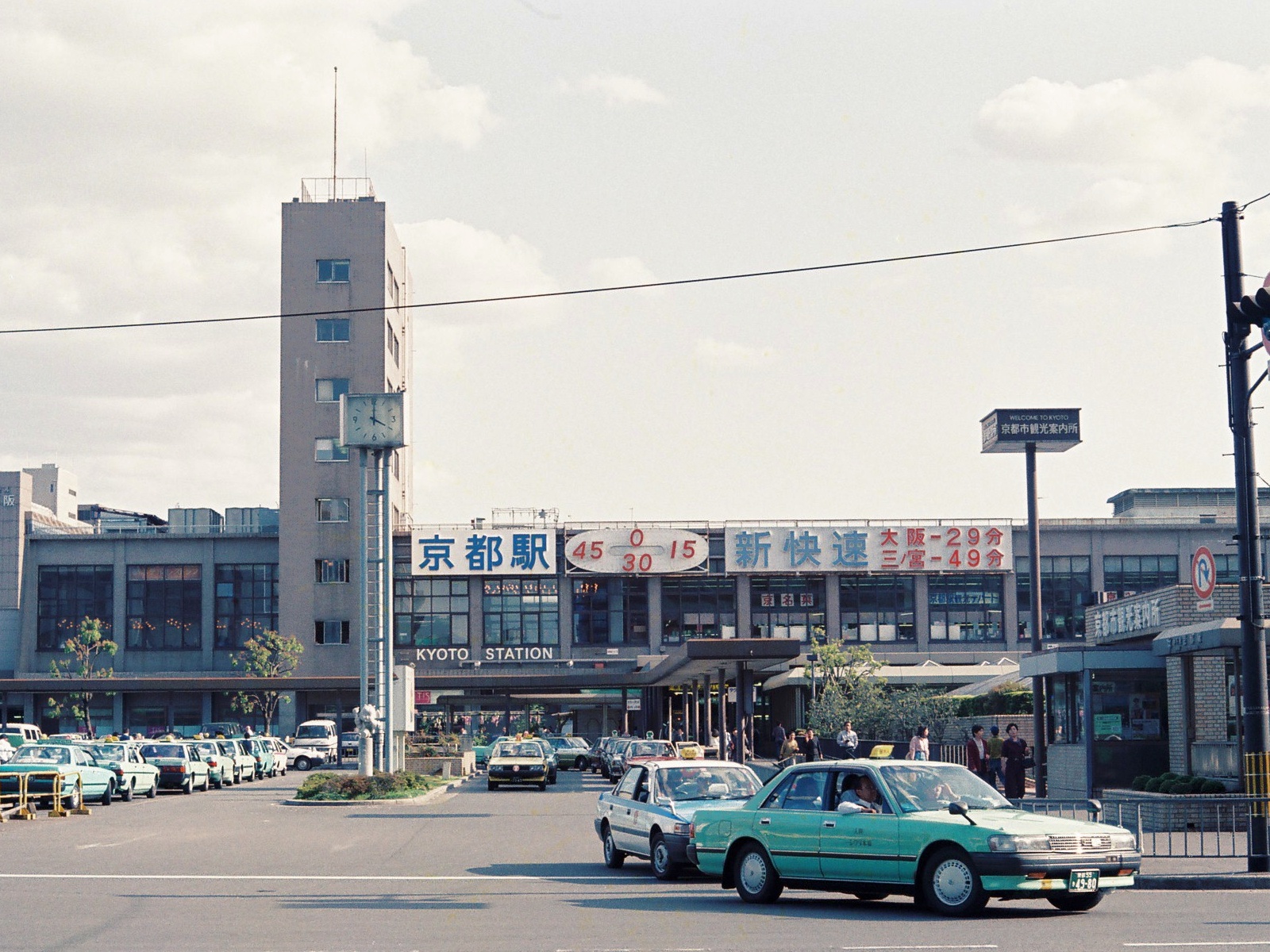
Kyoto Station is the luggage, rail and hotel-area anchor. Image: No machine-readable author provided. Fg2 assumed (based on copyright claims). / Public domain.
- Credit
- No machine-readable author provided. Fg2 assumed (based on copyright claims).
- Source
- https://commons.wikimedia.org/wiki/File%3AKyoto_Station_C0389.jpg

CC BY-SA 3.0
Kyoto slow routes are represented by the Philosopher’s Path. Image: ::::=UT=:::: / CC BY-SA 3.0.
- Credit
- ::::=UT=::::
- Source
- https://commons.wikimedia.org/wiki/File%3APhilosopher'sPath_%40Kyoto_-_panoramio.jpg

CC BY-SA 3.0
Kinkaku-ji Kyoto is used to match the article's destination or travel topic. Image: Jaycangel / CC BY-SA 3.0.
- Credit
- Jaycangel
- Source
- https://commons.wikimedia.org/wiki/File%3AKinkaku-ji_the_Golden_Temple_in_Kyoto_overlooking_the_lake_-_high_rez.JPG

CC BY-SA 3.0
Evening views in Tokyo are represented by Tokyo Tower. Image: Kakidai / CC BY-SA 3.0.
- Credit
- Kakidai
- Source
- https://commons.wikimedia.org/wiki/File%3ATokyo_Tower_at_night_1.JPG

CC BY 4.0
Kamakura Great Buddha is used to match the article's destination or travel topic. Image: Marie-Sophie Mejan / CC BY 4.0.
- Credit
- Marie-Sophie Mejan
- Source
- https://commons.wikimedia.org/wiki/File%3AKamakura%2C_Daibutsu%2C_the_great_Buddha_1.jpg

CC BY-SA 2.0
Tokyo Monorail Haneda Airport is used to match the article's destination or travel topic. Image: Yamaguchi Yoshiaki from Japan / CC BY-SA 2.0.
- Credit
- Yamaguchi Yoshiaki from Japan
- Source
- https://commons.wikimedia.org/wiki/File%3ATokyo_monorail_-_Haneda_airport_view_from_Keihinjima_island_(488414141).jpg

CC BY 2.0
Hama-rikyu Gardens Tokyo is used to match the article's destination or travel topic. Image: . Ray in Manila / CC BY 2.0.
- Credit
- . Ray in Manila
- Source
- https://commons.wikimedia.org/wiki/File%3AHama-rikyu_Gardens%2C_Tokyo_(53142611913).jpg

CC BY-SA 3.0
Tokyo museum buffers work well around Ueno and national museums. Image: Carla Antonini / CC BY-SA 3.0.
- Credit
- Carla Antonini
- Source
- https://commons.wikimedia.org/wiki/File%3ANational_Tokyo_Museum-Ueno-Tokyo_entrance_garden.jpg

CC0
Ueno Park Tokyo is used to match the article's destination or travel topic. Image: Rijksmuseum / CC0.
- Credit
- Rijksmuseum
- Source
- https://commons.wikimedia.org/wiki/File%3AMensen_op_een_trap_in_het_Ueno-park_in_Tokyo_Ueno_Park%2C_at_Tokyo_(titel_op_object)%2C_RP-F-F01102-AY.jpg

CC BY-SA 3.0
Tokyo Bay half-day plans are represented by Odaiba and the waterfront. Image: Morio / CC BY-SA 3.0.
- Credit
- Morio
- Source
- https://commons.wikimedia.org/wiki/File%3A20030727_27_July_2003_Rainbow_Bridge_Tokyo_Harbar_Connecting_Bridge_1_Odaiba_Tokyo_Japan.jpg

CC BY 2.0
Shinjuku is a practical evening food and hotel base. Image: Lukas / CC BY 2.0.
- Credit
- Lukas
- Source
- https://commons.wikimedia.org/wiki/File%3AShinjuku_station%2C_Tokyo%2C_Japan_--_aerial_photo%2C_2008-04-11.jpg

CC0
Asakusa and Nakamise are classic Tokyo walking areas. Image: Daderot / CC0.
- Credit
- Daderot
- Source
- https://commons.wikimedia.org/wiki/File%3AShrines_-_Sensoji_Temple%2C_Asakusa%2C_Tokyo%2C_Japan_-_DSC02054.JPG

CC BY 2.5
Tokyo Station and Marunouchi make a practical first-day base. Image: LERK / CC BY 2.5.
- Credit
- LERK
- Source
- https://commons.wikimedia.org/wiki/File%3ATokyoMetro-M17-Tokyo-station-platform-20071031.jpg

CC BY 2.0
Shibuya Crossing Tokyo is used to match the article's destination or travel topic. Image: yeowatzup / CC BY 2.0.
- Credit
- yeowatzup
- Source
- https://commons.wikimedia.org/wiki/File%3AShibuya_Crossing%2C_Tokyo%2C_Japan_(6790070270).jpg
CC0
Ueno museum and park plans center on Ueno Park and nearby museums. Image: Rijksmuseum / CC0.
- Credit
- Rijksmuseum
- Source
- https://commons.wikimedia.org/wiki/File%3AMensen_op_een_trap_in_het_Ueno-park_in_Tokyo_Ueno_Park%2C_at_Tokyo_(titel_op_object)%2C_RP-F-F01102-AY.jpg
CC BY-SA 3.0
Evening views in Tokyo are represented by Tokyo Tower. Image: Kakidai / CC BY-SA 3.0.
- Credit
- Kakidai
- Source
- https://commons.wikimedia.org/wiki/File%3ATokyo_Tower_at_night_1.JPG
CC BY-SA 3.0
Evening views in Tokyo are represented by Tokyo Tower. Image: Kakidai / CC BY-SA 3.0.
- Credit
- Kakidai
- Source
- https://commons.wikimedia.org/wiki/File%3ATokyo_Tower_at_night_1.JPG
CC BY 2.0
Shinjuku is a practical evening food and hotel base. Image: Lukas / CC BY 2.0.
- Credit
- Lukas
- Source
- https://commons.wikimedia.org/wiki/File%3AShinjuku_station%2C_Tokyo%2C_Japan_--_aerial_photo%2C_2008-04-11.jpg

CC BY-SA 4.0
Tokyo train station platform is used to match the article's destination or travel topic. Image: LERK / CC BY-SA 4.0.
- Credit
- LERK
- Source
- https://commons.wikimedia.org/wiki/File%3ARinkai-line-R04-Tokyo-teleport-station-platform-20220101-143247.jpg

CC BY 2.0
Seafood morning plans are represented by Tokyo market scenes. Image: yeowatzup / CC BY 2.0.
- Credit
- yeowatzup
- Source
- https://commons.wikimedia.org/wiki/File%3ATsukiji_Fish_Market%2C_Tokyo%2C_Japan_(6936165279).jpg

CC BY-SA 3.0
Tokyo airport arrival planning starts with Haneda Airport wayfinding. Image: Mj-bird / CC BY-SA 3.0.
- Credit
- Mj-bird
- Source
- https://commons.wikimedia.org/wiki/File%3AShanghai_Airlines_at_Tokyo_International_(Haneda)_Airport.jpg
CC BY 3.0
Kyoto articles are represented by recognizable temple and historic street scenes. Image: Kovacs Bela-Hungary / CC BY 3.0.
- Credit
- Kovacs Bela-Hungary
- Source
- https://commons.wikimedia.org/wiki/File%3AKiyomizu-dera_Temple%2C_Kyoto_-_panoramio.jpg

CC BY 2.5
Higashiyama walks are represented by Kiyomizu-dera and nearby streets. Image: Oilstreet / CC BY 2.5.
- Credit
- Oilstreet
- Source
- https://commons.wikimedia.org/wiki/File%3AKiyomizu-dera_in_Kyoto-r.jpg
CC BY-SA 2.0
Kyoto night etiquette is represented by Gion or Pontocho streets. Image: einalem from Pontocho street in Nakagyo, Kyoto / CC BY-SA 2.0.
- Credit
- einalem from Pontocho street in Nakagyo, Kyoto
- Source
- https://commons.wikimedia.org/wiki/File%3APontocho_by_einalem_in_Kyoto.jpg

CC BY-SA 4.0
Arashiyama half-day plans are represented by its bamboo and riverside scenery. Image: Basile Morin / CC BY-SA 4.0.
- Credit
- Basile Morin
- Source
- https://commons.wikimedia.org/wiki/File%3ABamboo_Grove%2C_Arashiyama%2C_Kyoto%2C_Japan.jpg

CC0
Kyoto tea and craft routes are represented by Uji or central Kyoto craft streets. Image: おいでやす千年の都 / CC0.
- Credit
- おいでやす千年の都
- Source
- https://commons.wikimedia.org/wiki/File%3ATea_plant_in_Kowata%2C_Uji%2C_Kyoto.jpg
Public domain
Kyoto Station building is used to match the article's destination or travel topic. Image: No machine-readable author provided. Fg2 assumed (based on copyright claims). / Public domain.
- Credit
- No machine-readable author provided. Fg2 assumed (based on copyright claims).
- Source
- https://commons.wikimedia.org/wiki/File%3AKyoto_Station_C0389.jpg
CC BY 2.5
Kyoto side-trip choices are represented by Uji or Nara landmarks. Image: 663highland / CC BY 2.5.
- Credit
- 663highland
- Source
- https://commons.wikimedia.org/wiki/File%3AByodoin_Uji_Kyoto03s3s4110.jpg
Public domain
Kyoto Station is the luggage, rail and hotel-area anchor. Image: No machine-readable author provided. Fg2 assumed (based on copyright claims). / Public domain.
- Credit
- No machine-readable author provided. Fg2 assumed (based on copyright claims).
- Source
- https://commons.wikimedia.org/wiki/File%3AKyoto_Station_C0389.jpg

CC BY 2.5
Osaka food walks are represented by Dotonbori. Image: Terence Ong / CC BY 2.5.
- Credit
- Terence Ong
- Source
- https://commons.wikimedia.org/wiki/File%3ALotteria%2C_Dotonbori%2C_Osaka.JPG
Public domain
Osaka history plans are represented by Osaka Castle or Nakanoshima. Image: Wikimedia Commons contributor / Public domain.
- Credit
- Wikimedia Commons contributor
- Source
- https://commons.wikimedia.org/wiki/File%3AOsaka_Castle_Nishinomaru_Garden_April_2005.JPG

CC BY 2.0
Shin-Osaka Station Shinkansen is used to match the article's destination or travel topic. Image: Go Ikeda / CC BY 2.0.
- Credit
- Go Ikeda
- Source
- https://commons.wikimedia.org/wiki/File%3ATrain_station_sign_of_shin-Osaka_station_(Tokaido_Shinkansen).jpg
CC BY-SA 4.0
Kuromon Market Osaka is used to match the article's destination or travel topic. Image: Mr.ちゅらさん / CC BY-SA 4.0.
- Credit
- Mr.ちゅらさん
- Source
- https://commons.wikimedia.org/wiki/File%3AOsaka_Kuromon_Ichiba_Market_2017-12_(2).jpg
CC BY-SA 3.0
Kansai arrivals are represented by Kansai International Airport. Image: Wikimedia Commons contributor / CC BY-SA 3.0.
- Credit
- Wikimedia Commons contributor
- Source
- https://commons.wikimedia.org/wiki/File%3AKansai_International_Airport_North_Terminal.jpg
CC BY-SA 3.0
Nara timing advice is represented by Nara Park and temple areas. Image: User:uniquex / CC BY-SA 3.0.
- Credit
- User:uniquex
- Source
- https://commons.wikimedia.org/wiki/File%3AA_deer_at_Nara_Park%2C_Japan.jpeg
CC BY-SA 3.0
Kobe side trips are represented by Kobe harbor or Arima Onsen. Image: Pastern / CC BY-SA 3.0.
- Credit
- Pastern
- Source
- https://commons.wikimedia.org/wiki/File%3AKobe_Harborland_001.JPG
CC BY 2.5
Theme-park rest-day planning is represented by Universal Studios Japan. Image: Terence Ong / CC BY 2.5.
- Credit
- Terence Ong
- Source
- https://commons.wikimedia.org/wiki/File%3ARoad_leading_to_Universal_Studios_Japan.JPG
CC BY-SA 3.0
Sapporo travel planning is represented by Odori Park and central Sapporo. Image: Nkns / CC BY-SA 3.0.
- Credit
- Nkns
- Source
- https://commons.wikimedia.org/wiki/File%3AHokkaido_Sapporo_Odori_Park.jpg
CC BY-SA 4.0
Hokkaido snow road is used to match the article's destination or travel topic. Image: Sgroey / CC BY-SA 4.0.
- Credit
- Sgroey
- Source
- https://commons.wikimedia.org/wiki/File%3ARural_road_in_Hokkaido_in_winter_showing_edge_markers.jpg
CC BY-SA 3.0
Hokkaido flower and farm routes are represented by Furano or Biei. Image: User:SElefant / CC BY-SA 3.0.
- Credit
- User:SElefant
- Source
- https://commons.wikimedia.org/wiki/File%3AFurano-Biei_Norokko_Train.jpg
Public domain
Hakodate night view is used to match the article's destination or travel topic. Image: Lombroso / Public domain.
- Credit
- Lombroso
- Source
- https://commons.wikimedia.org/wiki/File%3ANight_view_of_Hakodate.jpg

Attribution
Northern Hokkaido routes are represented by Cape Soya. Image: Ministry of Land, Infrastructure and Transport of Japan / Attribution.
- Credit
- Ministry of Land, Infrastructure and Transport of Japan
- Source
- https://commons.wikimedia.org/wiki/File%3AHokkaido-wakkanai-Cape-Soya-1977.jpg
CC BY 2.5
Hokkaido onsen and volcano routes are represented by Lake Toya or Noboribetsu. Image: 663highland / CC BY 2.5.
- Credit
- 663highland
- Source
- https://commons.wikimedia.org/wiki/File%3A130922_Lake_Toya_Toyako_Hokkaido_Japan01s5.jpg
CC BY-SA 3.0
Hokkaido flower and farm routes are represented by Furano or Biei. Image: User:SElefant / CC BY-SA 3.0.
- Credit
- User:SElefant
- Source
- https://commons.wikimedia.org/wiki/File%3AFurano-Biei_Norokko_Train.jpg

CC BY-SA 4.0
Noboribetsu Onsen Hokkaido is used to match the article's destination or travel topic. Image: Calistemon / CC BY-SA 4.0.
- Credit
- Calistemon
- Source
- https://commons.wikimedia.org/wiki/File%3AJigokudani_(Hell_Valley)%2C_Noboribetsu_Onsen%2C_Hokkaido%2C_April_2023_03.jpg

CC BY-SA 3.0
Manzamo Okinawa is used to match the article's destination or travel topic. Image: CEphoto, Uwe Aranas / CC BY-SA 3.0.
- Credit
- CEphoto, Uwe Aranas
- Source
- https://commons.wikimedia.org/wiki/File%3AOnna_Okinawa_Japan_Cape-Manzamo-01.jpg
CC0
Naha first-evening plans are represented by Kokusai-dori or the monorail. Image: Naha Mama Pavilionz / CC0.
- Credit
- Naha Mama Pavilionz
- Source
- https://commons.wikimedia.org/wiki/File%3AJP_%E6%97%A5%E6%9C%AC_Japan_%E6%B2%96%E7%B9%A9_OKINAWA_%E9%82%A3%E9%9C%B8_Naha_%E5%9C%8B%E9%9A%9B%E9%80%9A_Kokusai-dori_sign_route_January_2025_R12S_02.jpg
Public domain
Yaeyama base choices are represented by Ishigaki Island scenery. Image: NASA / Public domain.
- Credit
- NASA
- Source
- https://commons.wikimedia.org/wiki/File%3ASTS043-608-38_Ishigaki_Island.jpg
CC BY 2.5
Miyako routes are represented by beaches and island bridges. Image: 663highland / CC BY 2.5.
- Credit
- 663highland
- Source
- https://commons.wikimedia.org/wiki/File%3AYonahamaehama_Miyakojima_Okinawa_Japan01bs3s4592.jpg
CC BY-SA 3.0
Okinawa planning is represented by main-island and outer-island beach scenery. Image: Mokkie / CC BY-SA 3.0.
- Credit
- Mokkie
- Source
- https://commons.wikimedia.org/wiki/File%3AKouri_beach%2C_Okinawa.jpg
Public domain
Okinawa snorkeling advice is represented by reef and beach scenery. Image: Signal Corps Archive from Ireland and United States / Public domain.
- Credit
- Signal Corps Archive from Ireland and United States
- Source
- https://commons.wikimedia.org/wiki/File%3ASC_205560_-_This_is_an_aerial_view_of_the_beach_at_Okinawa_a_few_days_after_Tenth_Army_troops_moved_ashore._(51362208315).jpg
CC BY-SA 4.0
Tokaido Shinkansen N700 is used to match the article's destination or travel topic. Image: Charlie fong / CC BY-SA 4.0.
- Credit
- Charlie fong
- Source
- https://commons.wikimedia.org/wiki/File%3AN700_in_Tokaido_Shinkansen_%26Mt.Fuji.jpg
CC BY 2.0
IC card travel in Tokyo is best illustrated by station gates and Suica/PASMO use. Image: Tim Adams from San Francisco / CC BY 2.0.
- Credit
- Tim Adams from San Francisco
- Source
- https://commons.wikimedia.org/wiki/File%3A%E3%81%AE%E3%82%8A%E3%81%93%E3%81%97%E7%B2%BE%E7%AE%97_2014_(13154067205).jpg
CC BY-SA 4.0
Tokaido Shinkansen N700 is used to match the article's destination or travel topic. Image: Charlie fong / CC BY-SA 4.0.
- Credit
- Charlie fong
- Source
- https://commons.wikimedia.org/wiki/File%3AN700_in_Tokaido_Shinkansen_%26Mt.Fuji.jpg
CC BY 2.0
Luggage planning is represented by station storage and transfer scenes. Image: MiNe / CC BY 2.0.
- Credit
- MiNe
- Source
- https://commons.wikimedia.org/wiki/File%3ASign_of_How_to_use_a_Coinlocker_in_Shinjuku_Station.jpg

CC BY 3.0
Cherry blossom planning is represented by seasonal sakura scenery. Image: Yascolo / CC BY 3.0.
- Credit
- Yascolo
- Source
- https://commons.wikimedia.org/wiki/File%3AYoung_Cherry_Blossoms_In_Japan_(147452537).jpeg

CC BY-SA 4.0
Autumn route planning is represented by seasonal foliage. Image: Another Believer / CC BY-SA 4.0.
- Credit
- Another Believer
- Source
- https://commons.wikimedia.org/wiki/File%3APark_area_with_autumn_colors_between_streets_in_Kyoto%2C_Japan_(2019)_-_049.jpg

CC BY 3.0
Onsen etiquette is represented by a Japanese hot spring town or bath area. Image: photopond jp / CC BY 3.0.
- Credit
- photopond jp
- Source
- https://commons.wikimedia.org/wiki/File%3ADogo_Onsen_Hot_Spring%2C_Matsuyama_City%2C_Ehime_Prefecture%2C_Japan_-_panoramio.jpg

CC BY-SA 3.0
Fast foods of Lawson convenience store is used to match the article's destination or travel topic. Image: Corpse Reviver / CC BY-SA 3.0.
- Credit
- Corpse Reviver
- Source
- https://commons.wikimedia.org/wiki/File%3AFast_foods_of_Lawson_convenience_store.jpg
CC BY-SA 4.0
Japan earthquake preparedness sign is used to match the article's destination or travel topic. Image: Theodore Xu / CC BY-SA 4.0.
- Credit
- Theodore Xu
- Source
- https://commons.wikimedia.org/wiki/File%3ADisaster_Prevention_Warehouse_of_Nishicyokai%2C_Tokyo.jpg
CC BY 2.5
Tokyo Station and Marunouchi make a practical first-day base. Image: LERK / CC BY 2.5.
- Credit
- LERK
- Source
- https://commons.wikimedia.org/wiki/File%3ATokyoMetro-M17-Tokyo-station-platform-20071031.jpg

Wikimedia Commons media license
Tokyo neighborhoods are represented by Shibuya Crossing and central city movement. Image: Wikimedia Commons contributor / Wikimedia Commons media license.
- Credit
- Wikimedia Commons contributor
- Source
- https://commons.wikimedia.org/wiki/File:Tokyo_Shibuya_Scramble_Crossing_2018-10-09.jpg

Wikimedia Commons media license
A three-day Kyoto itinerary is represented by Kiyomizu-dera and the Higashiyama temple area. Image: Wikimedia Commons contributor / Wikimedia Commons media license.
- Credit
- Wikimedia Commons contributor
- Source
- https://commons.wikimedia.org/wiki/File:Kiyomizu-dera,_Kyoto,_November_2016_-01.jpg


